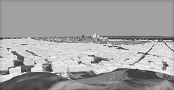
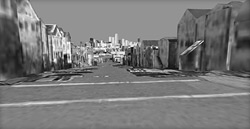
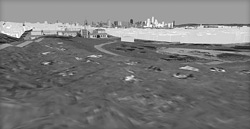
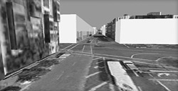
Central Corridor Plan Height Simulations
HOW TO READ THE SIMULATIONS
Scenario 1 : " Low Base" 
Scenario 2 : " Mid-Rise on Large Sites and Accent Key Corners" Scenario 4 " Taller Accent with 4th Street Spine" Scenario 3: " Taller Accent with Mission Bay Transition" Potential new buildings in the Central Corridor plan area are rendered in shades of tan to differentiate them from existing or already approved buildings. Buildings which are not yet built, but already approved or proposed in other plan areas (e.g. in Mission Bay, Rincon Hill, Transbay Redevelopment Area, Transit Center District Plan, Market/Octavia) are included and shown at their maximum envelopes in shades of blue or grey.
The tan "potential" building forms in the simulations do not represent actual building proposals or actual designs, skins, or shapes. They are simple geometric forms intended to show the maximum height and bulk of buildings at the locations being analyzed to assess changes to public views, skyline, and city form.
For each scenario, please refer to the corresponding height maps as shown in the Presentation from November 29, 2011 (pages 35-42). For ease of comparison and to show the greatest potential range of heights, all of the four height scenarios are modelled using Zoning scenario 4 (as shown in the Presentation from November 29, 2011 on page 18).
For an explanation of the factors and principles underlying the height scenarios, please review the November 29 presentation (pages 25-42). Below is a summary of the changes to height limits contained in each Scenario:
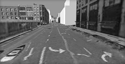
Existing Zoning
The heights in the plan area reflect existing zoning plus the currently proposed height limits in the Western SoMa Plan. |
Scenario 1 "Low Base"
- Major street frontages are 65' or 85'
- 120' - 150' emphasis at rail stations on 4th Street at Folsom, Brannan, and Townsend
- West side of 4th Street between Bryant and Brannan reduced from 65' to 45' to protect small lot pattern and small-scale neighborhood commercial businesses
- Heights sculpted on interior of block bounded by 4th, 5th, Bryant, and Brannan to reflect potential open space concept
- Heights sculpted adjacent to school site on Harrison between 4th and 5th
- Yerba Buena core blocks reduced from 340' to 85'; Community garden site on Lapu Lapu redcued from 130' to OS (Open Space)
- SW corner of 4th/Howard reduced from 340' to 130'
- North side Harrison east of 3rd increased from 85' to 130'
- Various alley sculpted heights, including along Bluxome and Clara.
|
Scenario 2 "Mid-Rise on Large Sites and Accent Key Corners"
Same as Scenario 1 except:
- 160' - 180' exmphasis at rail stations
- 120' allowed on large sites in growth areas (south side of Harrison Street and southwest-ward) and on key corners on 3rd and 4th Streets
- West side of 4th Street between Bryant and Brannan kept at existing 65' limit
- North side of Brannan between 3rd and 2nd increased from 45' to 65'
|
Scenario 3 "Taller Accent with Mission Bay Transition"
Same as Scenario 2 except:
- 160' - 250' exmphasis at rail stations
- 160' small footprint housing towers permitted on large sites south of Byrant Street with commercial podium. (Note: This concept only viable with Zoning Scenarios that permit housing in these areas, as small footprint towers likely infeasible for commercial uses).
|
Scenario 4 "Taller Accent with 4th Street Spine"
Same as Scenario 3 except:
- 200' - 320' exmphasis at rail stations
- 160' small footprint housing towers permitted on large sites with commercial podium along 4th Street
|
THESE SIMULATIONS ARE FOR ILLUSTRATIVE PURPOSES ONLY
 © 2011 San Francisco Planning Department © 2011 San Francisco Planning Department |